About:
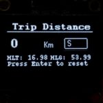
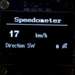
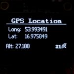
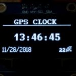
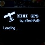
In this project we will learn how to interface GPS module with esp8266 as main controller to show GPS data on OLED display. We will read and display various elements from GPS like Speed, Clock, Date, Location, Altitude, Trip distance, Number of connected satellites, Cardinals (moving direction), etc. We can use this project in cars or other moving vehicles.
In next update I am planning to build a web-server using esp8266 to receive data from GPS in smart phones and generate geographical location on online 2D maps using longitude and latitude.
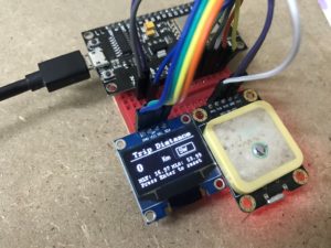
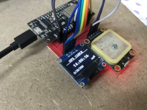
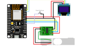
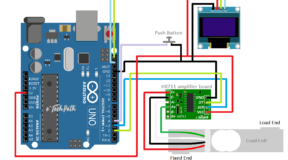
Components:
- ESP8266 NodeMCU board
- Ublox neo-6m GPS module
- OLED i2c display 128x64px
- Momentary push buttons – 2Nos
- Software : Arduino IDE
Circuit Diagram:

Code:
/* * Project: Mini GPS Display using Ublox neo-6m and ESP8266 * Author: Pranay SS, eTechPath * Website: www.etechpath.com * Tutorial Link:Mini GPS Display using Ublox neo-6m module and ESP8266 nodemcu* Video Link: https://youtu.be/ExPBmiz1cj0 * */ #include <Arduino.h> #include <U8g2lib.h> #ifdef U8X8_HAVE_HW_SPI #include <SPI.h> #endif #ifdef U8X8_HAVE_HW_I2C #include <Wire.h> #endif #define menu D3 #define enter D4 int key = 0; double Home_LAT = 0; double Home_LNG = 0; //sat20x20px logo U8G2_SSD1306_128X64_NONAME_1_HW_I2C u8g2(U8G2_R0, /* reset=*/ U8X8_PIN_NONE); static const unsigned char u8g_logo_sat[] U8X8_PROGMEM = { 0x00, 0x01, 0x00, 0x80, 0x07, 0x00, 0xc0, 0x06, 0x00, 0x60, 0x30, 0x00, 0x60, 0x78, 0x00, 0xc0, 0xfc, 0x00, 0x00, 0xfe, 0x01, 0x00, 0xff, 0x01, 0x80, 0xff, 0x00, 0xc0, 0x7f, 0x06, 0xc0, 0x3f, 0x06, 0x80, 0x1f, 0x0c, 0x80, 0x4f, 0x06, 0x19, 0xc6, 0x03, 0x1b, 0x80, 0x01, 0x73, 0x00, 0x00, 0x66, 0x00, 0x00, 0x0e, 0x00, 0x00, 0x3c, 0x00, 0x00, 0x70, 0x00, 0x00 }; //wave10px logo static const unsigned char u8g2_logo_wave[] U8X8_PROGMEM ={ 0xE0, 0x03, 0x18, 0x00, 0xC4, 0x01, 0x32, 0x00, 0x8A, 0x01, 0x69, 0x00, 0x25, 0x00, 0x95, 0x01, 0x95, 0x01, 0x01, 0x00, }; //sat40x35px logo // The serial connection to the GPS device #include <SoftwareSerial.h> static const int RXPin = D5, TXPin = D6; static const uint32_t GPSBaud = 9600; SoftwareSerial ss(RXPin, TXPin); //GPS Library #include <TinyGPS++.h> TinyGPSPlus gps; //Program variables double Lat; double Long; double Alt; int day, month, year; //int hour, minute, second; int num_sat, gps_speed; String heading; //SETUP void setup() { pinMode(menu, INPUT_PULLUP); pinMode(enter, INPUT_PULLUP); ss.begin(GPSBaud); u8g2.begin(); //PrintingLoadingPage u8g2.firstPage(); do { print_page1(); } while ( u8g2.nextPage() ); delay(5000); }//END SETUP //LOOP void loop() { Get_GPS(); //Get GPS data if (digitalRead(menu) == LOW) key = (key+1); //else if (digitalRead(menu) == LOW) //key = (key-1); if (key<0 or key>3) key = 0; switch (key) { case 0: u8g2.firstPage(); do { print_Clock(); } while ( u8g2.nextPage() ); delay(10); break; case 1: u8g2.firstPage(); do { print_speed(); } while ( u8g2.nextPage() ); delay(10); break; case 2: u8g2.firstPage(); do { print_location(); } while ( u8g2.nextPage() ); delay(10); break; case 3: u8g2.firstPage(); do { print_Trip(); if (digitalRead(enter) == LOW) { Home_LAT = gps.location.lat(); Home_LNG = gps.location.lng(); } else { u8g2.setFont(u8g2_font_courR08_tr); u8g2.setCursor(0, 64); u8g2.print("Press Enter to reset"); } } while ( u8g2.nextPage() ); delay(10); break; } } //end of loop void print_page1() { u8g2.drawXBMP(0, 0, 20, 20, u8g_logo_sat); u8g2.setFont( u8g2_font_crox1cb_tf); //u8g2.setFont(u8g2_font_helvB12_tf); //u8g2.setFont(u8g2_font_timB12_tf); u8g2.setCursor(45, 20); u8g2.print("MINI GPS"); //u8g2.setFont(u8g2_font_7x13B_tf); u8g2.setFont(u8g2_font_nine_by_five_nbp_tf); u8g2.setCursor(55, 35); u8g2.print("by eTechPath"); u8g2.setFont(u8g2_font_nine_by_five_nbp_tf); u8g2.setCursor(0, 60); u8g2.print("Loading"); u8g2.setFont(u8g2_font_glasstown_nbp_tf); u8g2.setCursor(40, 60); u8g2.print(" . . . . . "); } void print_Clock() { u8g2.setFont(u8g2_font_courB08_tn); u8g2.setCursor(105, 64); u8g2.print( num_sat, 5); u8g2.drawXBMP(118, 54, 10, 10, u8g2_logo_wave); u8g2.setFont(u8g2_font_crox1cb_tf); u8g2.setCursor(20, 10); u8g2.print("GPS CLOCK"); u8g2.drawLine(0,12,128,12); u8g2.setFont(u8g2_font_t0_22b_tn); u8g2.setCursor(20, 42); printTime(gps.time); // u8g.print(gps.date); //Get_Date(); u8g2.setFont(u8g2_font_nine_by_five_nbp_tf); u8g2.setCursor(0, 64); printDate(gps.date); } void print_speed() { u8g2.setFont(u8g2_font_crox1cb_tf); u8g2.setCursor(16, 10); u8g2.print("Speedometer"); u8g2.drawLine(0,15,128,15); u8g2.setFont(u8g2_font_t0_22b_tn); u8g2.setCursor(5, 42); u8g2.print(gps_speed , DEC); u8g2.setFont(u8g2_font_glasstown_nbp_tf); u8g2.setCursor(62, 42); u8g2.print("km/h"); u8g2.setFont(u8g2_font_courB08_tn); u8g2.setCursor(105, 64); u8g2.print( num_sat, 5); u8g2.drawXBMP(118, 54, 10, 10, u8g2_logo_wave); u8g2.setFont(u8g2_font_glasstown_nbp_tf); u8g2.setCursor(0,64); u8g2.print("Direction:"); u8g2.setCursor(45,64); u8g2.print( heading); } void print_location() { u8g2.setFont(u8g2_font_crox1cb_tf); u8g2.setCursor(10, 10); u8g2.print("GPS Location"); u8g2.drawLine(0,12,128,12); u8g2.setFont(u8g2_font_nine_by_five_nbp_tf); u8g2.setCursor(5, 28); u8g2.print("Long: "); u8g2.setCursor(40, 28); u8g2.print( Long, 6); u8g2.setCursor(5, 43); u8g2.print("Lat: "); u8g2.setCursor(40, 43); u8g2.print( Lat, 6); u8g2.setCursor(0, 64); u8g2.print("Alt: "); u8g2.setCursor(20, 64); u8g2.print( Alt, 3); u8g2.setFont(u8g2_font_courB08_tn); u8g2.setCursor(105, 64); u8g2.print( num_sat, 5); u8g2.drawXBMP(118, 54, 10, 10, u8g2_logo_wave); } // This custom version of delay() ensures that the gps object // is being "fed". static void smartDelay(unsigned long ms) { unsigned long start = millis(); do { while (ss.available()) gps.encode(ss.read()); } while (millis() - start < ms); } void Get_GPS() { num_sat = gps.satellites.value(); if (gps.location.isValid() == 1) { Lat = gps.location.lat(); Long = gps.location.lng(); Alt = gps.altitude.meters(); gps_speed = gps.speed.kmph(); heading = gps.cardinal(gps.course.value()); } /* if (gps.date.isValid()) { day = gps.date.day(); month = gps.date.month(); year = gps.date.year(); } if (gps.time.isValid()) { hour = gps.time.hour(); minute = gps.time.minute(); second = gps.time.second(); } */ smartDelay(1000); if (millis() > 5000 && gps.charsProcessed() < 10) { // Serial.println(F("No GPS detected: check wiring.")); } } static void printDate(TinyGPSDate &d) { if (!d.isValid()) { u8g2.print(F("******** ")); } else { char sz[32]; sprintf(sz, "%02d/%02d/%02d ", d.month(), d.day(), d.year()); u8g2.print(sz); } } static void printTime(TinyGPSTime &t) { if (!t.isValid()) { u8g2.print(F("******** ")); } else { char sz[32]; sprintf(sz, "%02d:%02d:%02d ", t.hour(), t.minute(), t.second()); u8g2.print(sz); } // printInt(d.age(), d.isValid(), 5); smartDelay(0); } void print_Trip() { unsigned long distanceKm = (unsigned long)TinyGPSPlus::distanceBetween( gps.location.lat(), gps.location.lng(), Home_LAT, Home_LNG ) / 1000.0; u8g2.setFont(u8g2_font_nine_by_five_nbp_tf); u8g2.setCursor(0, 20); u8g2.print("Trip: "); u8g2.setCursor(50, 20); u8g2.print(distanceKm); u8g2.setCursor(90, 20); u8g2.print("Km"); double courseTo = TinyGPSPlus::courseTo( gps.location.lat(), gps.location.lng(), Home_LAT, Home_LNG ); u8g2.setCursor(0, 30); u8g2.print("Course: "); u8g2.setCursor(60, 30); u8g2.print(courseTo); u8g2.setCursor(90, 30); u8g2.print("Km"); String cardinalTo = TinyGPSPlus::cardinal(courseTo); u8g2.setCursor(0, 40); u8g2.print("Cardinal: "); u8g2.setCursor(60, 40); u8g2.print(cardinalTo); }
Prototype: